Albemarle Sound in 1775
The detail of the Albemarle Sound region is a famous 1775 map of North and South Carolina by Henry Mouzon, Jr. The map was printed in England and also reproduced in a slightly smaller size than the original. It was the map used by American, British, and French forces. So, in looking at the fragment reproduced here, a person might imagine that he is a Revolutionary War general, studying the little towns, the ports, and roads that wander through the country, and trying to understand why a town is where it is, what military importance it has, or how it might be protected or destroyed. Through Albemarle Sound runs a dotted line indicating the course for ships. It may be seen where they could escape to or enter from the Atlantic through the narrow, hazardous Roanoke Inlet. To the left near where the Chowan River empties into the Sound, is the town of Edenton.
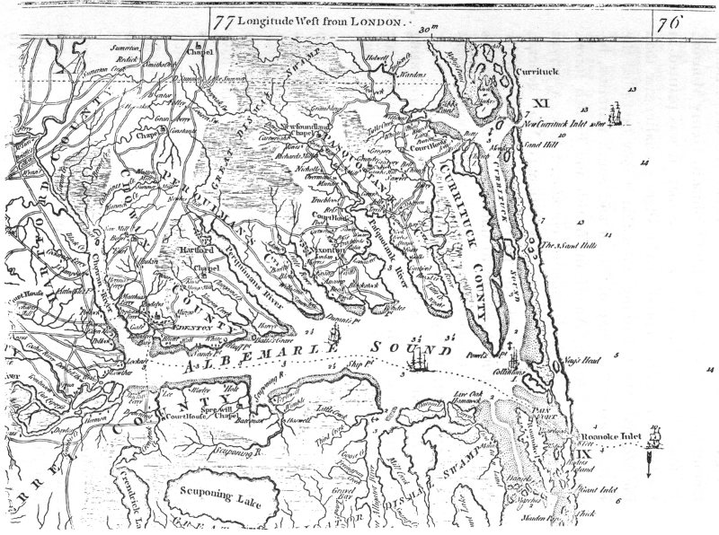
Several roads came together here, and the little black rectangles suggest buildings. There is a church in the town with a tower and steeple in front. Other churches shown elsewhere on the map have exactly the same form like the one at Edenton, so one realizes that this form is not meant to show what a specific church looked like, but is a standard symbol for a church. Incidentally, notice how churches or chapels stand-alone in various places in the countryside. Courthouses, like churches, are shown in towns, and here and there in the country. They are indicted by a symbol which could be described as a letter U which is squared rather than rounded. The courthouse at Edenton is difficult to identify on the map, however, following the Perquimans River, the town of Hertford (formerly called Hartford) situated farther to the east is Nixonton, its houses lying along both sides of a single road. Follow the road to the south and see the farms which lie along Little River. Each farm is marked by a spot representing the house, and carries the name of the owners; viz; Morris, Evans, Ancoup, and so on, can be read. In the north, above this area, is the Great Dismal Swamp.

Names of Families in Albemarle County, North Carolina Probate Records
The former county of Albemarle County was established in 1664 and was located in the northeastern portion of North Carolina. The county was named after the first Duke of Albemarle (George Monck), who was one of the eight Lords Proprietors of the Province of Carolina, for whom the Albemarle Sound is also named. Under the original divisions of the province, the county to the south of Albemarle was called Clarendon County and centered on the Cape Fear region, but was only briefly occupied in the 1660s. Bath County was organized in 1696 and lay more closely to the south. By 1670 the four precincts of Albemarle County had been formed: Shaftesbury, Currituck, Pasquotank, and Berkeley. In 1681, Berkeley was renamed Perquimans and in 1685 Shaftesbury became Chowan. By 1689 the county ceased to function as a governmental unit and was replaced by the four precincts. However, Albemarle County was officially abolished in 1739. The Higher Court of North Carolina functioned in Albemarle County.
Albemarle County (now extinct) Records available to members of North Carolina Pioneers
- Higher Court Records 1670 to 1696